1

BAYOU STATE TRAIL ASSOCIATION

Established 2021

The Bayou State Trail

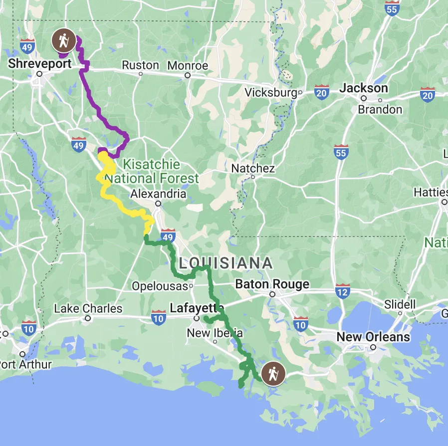
The Bayou State Trail runs nearly 500 miles across the state of Louisiana, highlighting the cultural and geographic diversity of three distinct regions: North Louisiana, Central Louisiana, and South Louisiana.

North Louisiana:

At a length of approximately 170 miles, this region showcases Louisiana's conservation legacy with several public lands for recreational use. The northern terminus of the Bayou State Trail is located at Ivan Lake Recreation Area, just north of Shreveport. From here, the trail winds its way through Bodcau Wildlife Management Area, the Caney Ranger District of Kisatchie National Forest, and several towns before hitting the "Louisiana Trails" Rails-to-Trails corridor for a wet and wild 50 miles! Further south, hikers enter the Winn Ranger District of Kisatchie, where they are greeted by the Gum Springs Trail and the birthplace of legendary Louisiana conservationist Caroline Dormon. Just across the Red River, the historic City of Natchitoches marks the southernmost point of the North Louisiana section.

Central Hills:

Considered the Crossroads of Louisiana, this region features 130 miles of rugged hills and scenic vistas on some of the Bayou State Trail's most remote terrain. Outside of Natchitoches, hikers will find solitude on a 14 mile levee walk on the bank of the Red River before entering the Kisatchie Ranger District. An alternate route follows the Cane River past Fort St. Jean Baptiste State Historic Site and Cane River Creole National Historic Park. Once in Kisatchie, the BST follows the popular Sandstone, Backbone, and Caroline Dormon trails. Next, the BST ventures into the Calcasieu Ranger District, where the 26 mile Wild Azalea Trail awaits! Further south, the Claiborne Trail System winds its way through the ruins of Camp Claiborne, an abandoned WWII training camp.


Acadiana:

The final 200 miles of the Bayou State Trail travels through the heart of Cajun Country. In the Acadiana region hikers will experience steep embankments on the shores of Lake Chicot, authentic cajun culture, and the wild majesty of the North America's largest river swamp: the Atchafalaya Basin. Walk along the bayou down to Chicot State Park, where the 20 mile Chicot Loop Trail finishes just north of Ville Platte, the Swamp Pop Capitol of the World. Just west of here, the BST joins the Atchafalaya Levee, leading to Pat's Fisherman's Wharf Restaurant and Zydeco Dance Club in the town of Henderson. Another 55 miles along the Atchafalaya Wilderness Trail takes hikers past the Lake Martin spur trail, Lake Fausse Pointe State Park, and several airboat swamp tour outfitters! At the end the levee, hikers can decide to continue to the southern terminus of the Bayou State Trail in Morgan City or choose to take another spur trail through Bayou Teche National Wildlife Refuge and finish in the Gulf of Mexico.

***Closures/Reroutes***

Bayou Dorcheat Bridge Closure

The Bayou Dorcheat Bridge on LA-160, east of Cotton Valley, is under construction. Hikers should use the Bayou Dorcheat/LA-2 Reroute to bypass this closure.

Bodcau ATV Trail Closure

The Bodcau ATV Trail just south of Ivan Lake becomes overgrown and unclear after 2 miles. Hikers should use the Young Road Reroute to bypass this section.

1

1

The Bayou State Trail Association is a Louisiana non-profit organization.

Copyright © 2024 Bayou State Trail Association. All Rights Reserved.